Cities & Countries
FATMA AKGÜL-SÖKE YAVUZ SELİM ANATOLIAN HIGH SCHOOL -TÜRKİYE
https://youtu.be/oe_kmwcO1ag?si=ulZd38dgUq_HT_yO
https://youtube.com/watch?v=bMdPEutnjZo&si=lry77mNo9jhSEmWn
Diana Adumitroaei- National College "Cuza Voda"
Husi- Romania
https://www.youtube.com/watch?v=g3zbd6hjB_0
This is the town where our schools is IES Paco Mollá
(PETRER - ALICANTE - SPAIN)
Katarzyna Mrówka - Poland
Link to the short movie about Poland:
https://youtu.be/YCelkqmkxMs?si=VkQLMB3CpF3NOoQg
Twinboard
Kastamonu is a lovely city hidden in the midst of forests in Anatolia. The beauty of the 12th century Byzantine castle at the foot of the hill welcomes you. The 13th century Atabey Mosque and the Ibni Neccar Mosque are worth visiting. In the village of Kasaba you will have the opportunity to see one of the most elegant wood carvings of Turkey, on the Mahmut Bey Mosque.
The Ilgaz National Park is 63 kilometers (39 miles) south of Kastamonu. It is a perfect destination for mountaineering and especially for winter sports since there is a ski-center with good accommodation facilities. The landscape from the Ilgaz Mountain (2587 meters - 8490 feet) is breathtaking; you will want to take lots of photographs. The Kizilirmak River contributes to that marvelous picture of the city. The Ilgarini cave at Cide, the Alinca underground cave at Kure, and the International Equestrian Tourism Center of Daday are amongst other attractions.
Inebolu, 100 kilometers (62 miles) north of Kastamonu, is a typical Black Sea town, exhibiting fine examples of traditional Turkish architecture in the midst of greenery. To the east of lnebolu is the Abana holiday center. To the west is Cide with good hotels and sandy beaches, as well as the dreamlike Cideros Bay.
Hale Erol-Söke Adnan Menderes Vocational and Technical Anatolian High School
Introduction of Aydın/TÜRKİYE
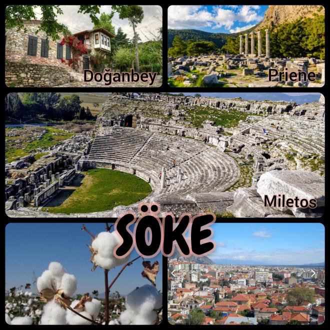
Our Town Söke/AYDIN
It was established in the central coastal region of the Aegean Sea, full of historical and natural beauties, near the Büyük Menderes river. The plain area that constitutes the fertile land of Söke is between the city and the Büyük Menderes River. The residential area of the city spreads towards the north and north-west sides of the plain.
It is 54 km from Aydın and 120 km from Izmir, and borders Koçarlı to the east, Germencik to the northeast, Kuşadası to the northwest, and Milas to the west.
Söke's surface area is 1088 km² and its average altitude above sea level is 23 meters. 50 km from the city. There is Lake Bafa in the distance. The lake lies within the borders of Söke and Milas.
There are Samson Mountains, Gümüş and Kemer Mountains in the north of Söke, and Beşparmak Mountains in the south. Söke has a typical Mediterranean climate. Summers are dry and hot, winters are warm and rainy. It receives almost no precipitation in the summer months. Most rainfall; It occurs in December, January and February. Precipitation is generally in the form of rain, and snowfall is very rare.
In Söke, there is the maquis, the characteristic vegetation of the Mediterranean Region. Black pine and stone pine grow in the higher parts of the mountains, olives grow on the mountain slopes, and figs and citrus fruits grow in the plain areas. Cultivated plants growing in the Söke plain are wheat, barley, oats, corn, etc. industrial plants; cotton, sunflower, sesame and canola.
GEOGRAPHICAL POSITION:
Söke is a cute and strong district with Izmir in the north, Didim and Muğla in the south, and Kuşadası in the west. Söke is located on fertile land at the last point of the Büyük Menderes Basin.
Caldas de Vizela - City
By Vizeldrone
Metković, Croatia


